OAS and SBAS
START OAS
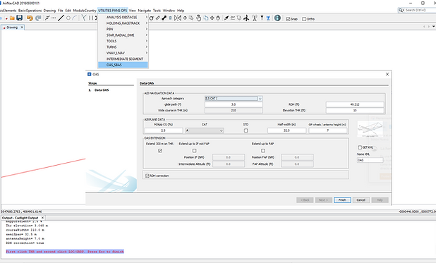
Click on Utilities PANS OPS and select OAS_SBAS, and the WIZARD appears. It's simply as program OAS from ICAO. AirNavCAD uses the tables From the ICAO program PANS-OPS OAS to generate OAS ILS. SBAS APV its derivate from OAS CATI as Attachment to Part III
DERIVATION OF THE SBAS OBSTACLE ASSESSMENT
SURFACES (OAS) tells.
WIZARD
Wizard is very easy to fill in, just enter the necessary data. You can extend OAS up to FAP, IF just introduce altitude in ft and Distance DME from THR.
Select OAS CATI, CATII, SBAS APV, SBAS CATI.
​
By default RDH Correction is checked as pans ops oas.
OAS areas
If you click Finish in the wizard The output tell you, you must click on THR and LOC / GARP.
​
After thar you get the OAS in the workspace, with the message and also with the parameters of Planes and Points.
OUTPUT
You can see the parameters of Planes and Points in the output component
INFO
If you select a plane from OAS you can get the information about how that OAS was built with the parameter and data input.
Analysis Obstacle
Click on
UTILITIES PANS OPS
OBSTACLE ANALYSIS
PANS OPS MAIN AREAS
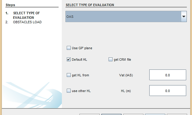
Select
OAS
and click next:
​
the obstacle data wizard appears, you have to load obstacle data and click Finish.
​
The output tell you select the Z plane from oas with red circle and evaluation stars. Select at the end of the plane Z.
Analysis Obstacle
It takes less than 2 minutes to analysis 200 m size cell from DEM (2,000,000 points) or
up to 10 minutes for 05 m size cell from DME (80,000,000 points)
​
You get the critical obstacle with a red circle (in layer criticalObstacles) in the drawing and also get the main data in output.
​
You can move the vertex / insert vertex of the areas to limit the area to analysis. Not CUT because information from OAS is LOST.
Analysis Obstacle
Also you get in the file of the analysis of the first 5000 or 10000 critical obstacle.
​
Including OCA estimation for all CATs.
KML
As any area you can export that area to KML.
​
First select all the oas area
then Click
Basic Operation
Transform to KML
​
And you get the KML in the folder of KML of the program
My Files / Documents / AirNavCAD / KML
CAT II
ILS Cat II: ILS Cat II OAS and those portions of ILS Cat I which lie above the limits of ILS Cat II; OAS CATII up to 150 M above threshold AND CAT I from 150 M to 300 M
HL adjust and GP prima plane
a) for airfield elevation higher than 900 m (2 953 ft)
b) for glide path angles greater than 3.2° upt to 3.5°.
c) User can edit HL with an IAS VAT or a choose one.
c) User can select method to consider obstacles on MA or Approach
ILS: Glide path angles above 3.5 °
a) the W surface of the OAS;
b) origin of the Z surface of the OAS; and
c) height loss / altimeter margin
Slope MissAproach
5.0% is the limit as in the tables is not indicated more.
VIDEO 3 OAS and SBAS